1-242-368-5171 

1-242-368-5171
Most if not all the flats accessible from the lodge will have bonefish on them at one time or another. However, at any one time, the fish will use only a small fraction of the area available to them. Exactly what makes the bones prefer one flat, or one area of a flat, over another any given day is complex and trying to figure this out is one of the great joys of DIY bonefishing. But this is not trivial, so….. if you want to catch lots of bones, go with a guide. They know where the bones will be and how to catch them. It will be great fun. If you want to hunt bones on your own and do not mind catching (generally) fewer fish, then keep reading.
Tides. Most of us find an awareness of the tides to be a useful guide for organizing our fishing. The reason tides matter is twofold. First, as every book tells you, the bones will follow the tide as it floods the flats and retreat with the falling tide, so that is a helpful guide for finding fish. However, there is a second reason that is every bit as important for those of us wading the flats; fish are difficult to see in deep water. There will be plenty of bones in 2+ feet of water and you could even get to them by wading, but very likely you will have trouble seeing them. So, the water depth, and hence the tides, narrow your options where to fish. Learning the flats is really learning the flats as they change with the tides.
The tide prediction locale closest to the lodge is Fresh Creek. In general, the predicted times for the tides at Fresh Creek are close to those observed around the lodge, although the absolute tide height tends to be more variable. The table may say that the low tide is at 0.89 feet but depending on winds etc the flats may not look exactly as previous days at 0.89. If you are fishing several days consecutively you will find that the absolute level of the tide is predictable from day to day, so this is not a big problem. However, if you are planning a trip, this variability is worth keeping in mind.
My favorite tide prediction web site is NOAA’s tides & currents - View Here
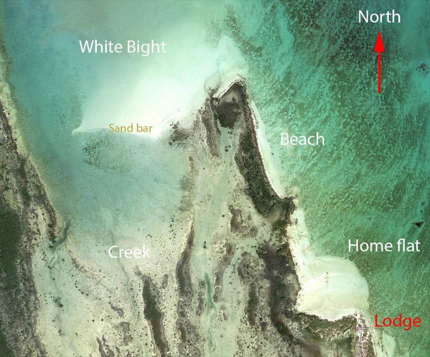
While the lodge offers a great base for exploring the flats fishing in central Andros, most DIY anglers start with the flats extending immediately north of the lodge (see illustration). Below is a brief introduction to this area.

The oceanside flats. Traveling northward from the lodge along the coast (oceanside of the peninsula) the angler finds first a small flat (the “home” flat) followed by a rocky point and then a long white sand beach. From the lodge to the tip of the peninsula it is about a mile as the crow flies. Anglers traveling on foot can follow a land trail that borders the water up to the tip of the peninsula. Both the home flat and the beach have hard light-sand bottoms and offer easy wading and good to excellent visibility. Both see cruising bones and are worth exploring on their own, or as the angler is on the way up to, or down from, White Bight.
The White Bight. An angler standing at the tip of the peninsula will see a small island (Man of War Cay) almost due north, and a vast white sand flat to his left, the White Bight. My first impression when I first saw this flat was that it was just about as classic a bonefish flat as one was likely to find anywhere. The entire flat is hard sand and slopes down very gently northward such that at extreme low tides the flat is easily wadeable halfway to Man of War Cay. The flat is surrounded by deep water, especially along the east and west, and most importantly, lays at the base of a large and productive tidal creek system immediately to the south. Bonefish move onto the flat from the deep water or from the mangroves and rivulets emptying the tidal creek system. Once on the flat they cruise purposely or feed in place in schools ranging from a few individuals to enormous schools containing hundreds of fish. Most importantly, with good light the fish are easy to spot on the light bottom and schools can be seen and/or stalked from long distances. Not infrequently the fish feed in such shallow water that the angler finds himself or herself stalking the backs and tails of dozens of the fish glistening in the sun. On a good day — which are not rare — this flat offers absolutely classic bonefishing at its very best. An angler can spend a month fishing this flat alone and not tire of it, I certainly haven’t. However, be forewarned that finding fish on the flat is not a given. The fish seldom use the entire flat (although it has been known to happen) and generally prefer one section over another, presumably reflecting local conditions and/or food availability. The keys to locating fish in this flat, as in all bonefishing, are tide and water depth, patience/attention/curiosity……luck and (especially) good eyes!
The Creek. The area between the west coast of the peninsula and the east coast of the island itself is home to a very large tidal creek system that extends from the lodge access road on the south up to White Bight on the north. This creek system floods to varying degrees during high tide, all the way up to the road on robust spring tides, barely at all in extreme neap tides, and the fish follow. A key feature of this tidal creek is that its mouth is partly blocked by a large sand bar — the southernmost edge of the White Bight. This barrier diverts the water at the late stages of the tide into a channel bordering the island (west) shore and creates a large basin at the base of the creek. The bones will cruise this basin as the tide begins to flood and will move into the creek proper as the water rises. As the tide ebbs and the water drops, they will exit the mangroves and feed on the basin and the flats of White Bight.
The main challenge for fishing this area is the bottom, which is mud of varying depth and hardness. Intrepid anglers in good physical condition can fish this whole area on foot, but for the rest of us access is more limited. The easiest area to access is the northern rim of the basin (sandbar edge), which offers firm footing and an excellent high vantage point for spotting fish. Foot access beyond that, while possible, is hard work and requires a high tolerance for wading through mud.
The Creek proper, above the basin, is a complex maze of limestone islands, mangrove thickets and channels that can be followed almost to the lodge. This is a beautiful area to explore, even if the fishing is generally quite a bit more challenging. On good days it is possible to find fish in the wide channels or open spaces offering clean shots, but just as frequently they will be in the mangroves. Even fish hooked in the clear will often seek refuge among the mangrove roots. Although access to the lower sections of the creek on foot is possible, this area is best explored using a kayak, just make sure you do not to get trapped as the tide drops. The easiest kayak access to the eastern section of the Creek, provided the water is high enough, is over a gnarly limestone ledge that regulars call “The Wall” (see second map). However this section may not be passable at low water levels and carrying the kayaks over the limestone is not advisable (you absolutely do not want to trip and fall here). Alternatively, at moderate flows, it is possible to kayak up the large stream that empties near the tip of the peninsula. This will take you over a small blue hole and through a narrow mangrove tunnel (watch your rod!) into the lowest point of the Creek.
There is of course much more fishing available from the lodge. But this is enough to get the first-time visitor started. One of the joys of fishing from Mt. Pleasant Fishing lodge is the learning the flats, little by little. No two trips are ever the same and each day reveals yet one more little bit about how the flats work. This is what brings many of us back year after year.
Enjoy your stay.
Rodrigo Andrade
Grosse Pointe, Michigan
October 2021